
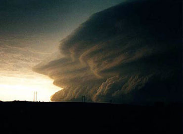
High pressure located in the upper and middle levels of the atmosphere often dominates weather cycles across the southern and central United States during the summer months. Occasionally, this high will migrate even farther northward to the northern tier of states, allowing tropical weather systems to encroach upon the deep south, bringing rain-cooled temperatures along with high humidity values. This year is different; those summer identifiers are a thing of the past. With the advent of El Nino, which developed offshore South America this spring, and is migrating northward into the tropical east Pacific this summer, the summertime high pressure (dome) has become entrenched over the the entire southern tier of states, and now extends eastward from California across Texas to areas of the deep south. Meanwhile, a strong almost springlike trough has remained over the Northeastern states, producing flooding rains at times.
This weather pattern is expected to persist for another month or so, at which time high pressure over the south will begin to break down, allowing intense tropical weather systems to approach both the Atlantic and Gulf Coasts. Please stay alert. The extreme heat wave across the deep south will intensify further over the next two weeks, and is likely to produce some challenge to the operation of electrical grids across portions of the south and southwestern U.S. As August wears on, the heat will subside, only to allow for the development and migration of the tropical systems mentioned above. Please stay alert. Some of these tropical cyclones (hurricanes) are sure to be blog-worthy !


Fantastic beat ! I wish to apprentice while you amend your web site,
how can i subscribe for a blog web site? The account aided me a acceptable deal.
I had been a little bit acquainted of this your broadcast provided bright clear idea
Wow!!!..John….you were on point all along…great forecasting…looking forward to more.
Thanks for your kind feedback, Jessica! I’ve posted another.
Hello, Jessica
How are you? I’m curious if you’ve seen my latest posts; hurricane Lee?
Nice blog here! Additionally your website quite a bit up very fast! What web host are you using? Can I am getting your associate link in your host? I want my web site loaded up as quickly as yours lol
You can certainly see your enthusiasm in the paintings you write. The world hopes for even more passionate writers such as you who are not afraid to say how they believe. Always go after your heart.
Excellent goods from you, man. I’ve understand your stuff previous to and you are just extremely excellent. I actually like what you’ve acquired here, certainly like what you’re saying and the way in which you say it. You make it entertaining and you still take care of to keep it wise. I can’t wait to read much more from you. This is actually a tremendous site.
I’m still learning from you, while I’m improving myself. I definitely liked reading everything that is posted on your site.Keep the information coming. I liked it!
This is a very good tips especially to those new to blogosphere, brief and accurate information… Thanks for sharing this one. A must read article.
Absolutely indited written content, Really enjoyed looking at.
You have brought up a very wonderful points, thankyou for the post.